
BRIMSON, Minn. — Some residents displaced by the three major wildfires burning in northeastern Minnesota this week received good news late Thursday night as wetter, cooler conditions gave crews a break.
St. Louis County Sheriff Gordon Ramsay announced in a Facebook video that the evacuation orders for the smaller Munger Shaw Fire northwest of Duluth had been lifted.
“Due to the more favorable weather conditions and successful work on preventing further spread, residents have been allowed to return to their properties beginning earlier (Thursday evening),” Ramsay said. “We appreciate everyone’s patience and understanding. The road closures that occurred so that the firefighters could do their work should be slowly lifted as well.”
Ramsay said that conditions for both the Munger Shaw and Camp House fires improved, though some hot spots popped up due to the wind picking up. The Camp House Fire saw some areas reignite, but Ramsey said crews were working hard to put them out. Evacuation orders are still in effect for residents affected by that fire near Brimson.
Ramsay also provided an update on the Jenkins Creek Fire, southeast of Hoyt Lakes.
“We had some worries this afternoon when that wind really picked up,” he said late Thursday. “It was gusting to the 30s. As the storm moved in, I heard in Hovland there was a gust of 74 mph. We were really concerned about that fire and what was happening with it. However, the rain came and diminished the worry significantly. The winds also died down.”
On Friday morning, Ramsay announced on Facebook that “Fire Incident Command is temporarily allowing property owners to enter the evacuation zones of Jenkins Creek and Camp House fires until 8 p.m. today, May 16, 2025.
“All personnel wishing to enter must first check in with the deputies who are staged at Hugo‘s Bar for the Camp House area, or at County Road 16 and Forest Highway 11 for the Jenkins Creek area. Be prepared to give identification and proof of property ownership to deputies. Upon leaving the evacuation zone, everyone who entered must check out with deputies. Be vigilant and cautious when entering because of the possibility of hazards such as downed trees.”
Several elected officials visited the area Friday to survey the damage caused by the fires so far, including Gov. Tim Walz, U.S. Sens. Amy Klobuchar and Tina Smith, U.S. Rep. Pete Stauber and state Sen. Grant Hauschild.
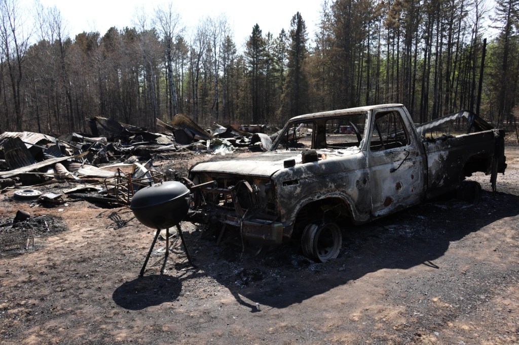
The Camp House Fire started Sunday, and the Jenkins Creek and Munger Shaw blazes broke out Monday amid critical fire conditions caused by high temperatures, strong winds and low humidity.
As of Friday morning’s updated assessment, the Camp House had burned nearly 15,000 acres, the Jenkins Creek had scorched more than 15,000 acres and the Munger Shaw had torched 1,600 acres. Only the Munger Shaw had any official level of containment, at 25%.
Authorities said they were still trying to determine what sparked the fires, which have been fueled by trees killed and defoliated by the spruce budworm.
Some 150 structures, including homes and cabins, have been destroyed. However, no serious injuries have been reported.
For questions about Camp House, Jenkins Creek fires
U.S. Forest Service hotline: 218-206-6805
Jenkins Creek Fire status, 9:17 a.m. Friday
- Started: Monday
- Acres: 15,571
- Location: East of Hoyt Lakes
- Cause: Under investigation
- Resources: 5 engines, 3 tenders, 3 tracked vehicles, air support, 63 personnel
- Containment: Zero percent
- Eastern Area Complex Incident Management Team notes: “The hot, windy weather in recent days led to some extreme fire behavior with crowning, torching and spread earlier in the week. Thursday night storms have mitigated some of that. Protection of the Skibo and Hoyt Lakes communities remains a priority operational objective. Firefighters continue to assess fire suppression control-line locations and dozers are extending and connecting those lines already developed. ‘Hot Shot’ crews have been inserted on this fire. The acreage total reflects accurate reports obtained via infrared reconnaissance flights.”
Camp House Fire status, 9:17 a.m. Friday
- Started: Sunday
- Acres: 14,852
- Location: Brimson
- Cause: Under investigation
- Resources: 32 engines, 13 tenders, 6 dozers, 3 tracked vehicles, air support, 264 personnel
- Containment: Zero percent
- Eastern Area Complex Incident Management Team notes: “Dozer crews advanced a containment line on the south end and west side of the fire and will implement direct attacks on those areas as conditions permit. A concerted effort has been made to protect the communications tower east of Bassett Lake. Crews are assessing the viability of setting up structure protection near Fairbanks. The fire is fueled by mixed forest vegetation and spruce budworm-infested forest stands. Dead and distressed balsam and aspen prone to ignition pose a significant hazard for firefighters. ‘Hot Shot’ crews are in the field. This fire has not grown, and the reduced acreage reported is the result of a more accurate scan by infrared reconnaissance flights.”
Munger Shaw Fire status, 11:10 a.m. Friday
- Started: Monday
- Acres: 1,600
- Location: 2 miles east of Elora Lake
- Cause: Under investigation
- Resources: 65 personnel, 1 engine, 2 dozers
- Containment: 25%
- Minnesota Interagency Command Team A notes: “The fire is active in pine and lowland fuels. St. Louis County Sheriff’s Office and Emergency Management are coordinating public safety efforts, including evacuations and road closures. Firefighters continue working to establish fire containment lines around the fire with heavy equipment and on-the-ground personnel. Temporary flight restrictions are in place. Today’s activities include strengthening and reinforcing existing containment lines and mop-up.”
Evacuations
St. Louis and Lake counties will contact residents in their respective counties if they need to evacuate.
- St. Louis County’s “ready, set, go!” evacuation zone map denotes evacuation status in yellow, orange and red, along with recommended plans to protect residents and their property.
- Lake County’s “ready, set, go!” evacuation zone map denotes evacuation status in yellow, orange and red, along with recommended plans to protect residents and their property.
Evacuation centers
- St. Louis County Public Health and American Red Cross shelter at the Fredenberg Community Center, 5104 Fish Lake Road, Duluth.
- Old School Lives, 9165 U.S. Highway 53, Cotton.
Weather forecast
The National Weather Service forecast for the fire area Friday calls for cloudy conditions with high temperatures near 53 degrees. Between a tenth and a quarter of an inch of rain is predicted with periodic rain showers throughout the day. Winds will be breezy from the south at 10-15 mph with gusts as high as 35 mph.
How you can help
United Way of Northeastern Minnesota
For residents impacted in St. Louis County. It is working to establish a wildfire recovery fund. Immediate assistance is offered through its Comforts of Home program, which replaces lost items with referrals from agencies like the Red Cross and St. Louis County. All proceeds go to impacted community members.
- Donate online: unitedwaynemn.org/firehelp
- Donate via mail: United Way of Northeastern Minnesota, 608 East Drive, Chisholm, MN 55719.
Head of the Lakes United Way
For residents impacted in Lake County. All proceeds go to impacted community members.
Originally Published: